AGRICULTURE
Hexagon US Federal offers several platforms to build web or mobile apps for your enterprise that streamline workflows, connect users and resources, and bring powerful geospatial visualization and analytics to your users. The end result - improved situational awareness and decision making.

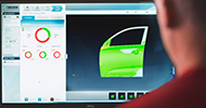
M.AppX is a cloud-based exploitation solution that provides analysts and other intelligence professionals with vital functionality for executing a full range of tasks through a 100 percent browser-based, zero-footprint architecture. Extend out-of-the-box M.AppX functionality by easily building custom web services based on spatial models.
Contact us today at info@hexagonusfederal.com for more information on or visit:
M.App X | Hexagon Safety, Infrastructure, and Geospatial
We provide the ability to easily and quickly build self-contained 2D and 3D geospatial applications called “Smart M.Apps” with no coding required. Smart M.Apps come equipped with a rich set of predefined Business Intelligent widgets that enable you to visualize powerful trends in your data.
Contact us today at info@hexagonusfederal.com for more information on Smart M.Apps or visit:
M.App Enterprise | Hexagon Safety, Infrastructure, and Geospatial
GEEP is an enhanced and secure version of Google Earth Enterprise that allows you to manage your own raster, vector, and terrain data with an amazing, enhanced user experience, and within a variety of environments including tactical, enterprise, mobile, and comms-denied.
Contact us today at info@hexagonusfederal.com for more information on GEEP.
Xalt | Mobility is a cloud-based enterprise software platform that lets you quickly build robust mobile apps to solve your specific business and operational challenges. Our groundbreaking technology connects your administrative database systems and enterprise applications to your valued users on any PC browser or mobile device.
Xalt | Mobility enables:
Contact us today at info@hexagonusfederal.com for more information on Xalt.
LuciadMobile is optimized for running rich geospatial applications in the field, such as mobile terrain analysis, military symbology, and other features that enhance field-based decision making.
LuciadMobile includes deep integration with Android OS, providing access to the functions of the device, such as camera, compass, and GPS. Its small software footprint runs efficiently on mobile hardware resources and provides controllable battery usage.
Contact us today at info@hexagonusfederal.com for more information on LuciadMobile or visit:
LuciadMobile | Hexagon Geospatial
Use LuciadRIA to develop powerful 2D and 3D web applications using WebGL, HTML5, and JavaScript to achieve desktop-like performance. Build stunning applications such as dynamic common operating pictures (COPs) that incorporate satellite and other imagery, vector-based data, and dynamic content, including tracked vehicles and aircraft.
For more information on our Geospatial solutions and content, please contact us today at